Welcome to our blog, where we embark on a virtual expedition to uncover the hidden aquatic treasures nestled within the arid landscapes of Egypt. This blog seeks to unravel the mysteries and beauty hidden within these Egyptian lakes, offering readers a unique perspective on the country’s aquatic landscapes. From natural wonders to man-made reservoirs, each lake tells a story of adaptation, survival, and the delicate balance between nature and human intervention.
Join us on a virtual journey as we explore the lakes of Egypt, from the colossal reservoirs born out of modern engineering feats to the serene coastal lagoons that echo ancient tales. Delve into the significance of these water bodies in sustaining life, supporting ecosystems, and contributing to Egypt’s cultural and historical tapestry. Whether you’re a traveler seeking off-the-beaten-path destinations or a curious mind eager to learn about lesser-known facets of Egypt, this blog aims to guide you to the hidden aquatic gems that make the landscape of Egypt even more enchanting.
⬇️⬇️GET 25% OFF OF YOUR TRIP TO EGYPT 2024/2025 ⬇️⬇️
How many lakes are in Egypt?
Egypt has several lakes, ranging from large bodies of water to smaller lakes and lagoons. Some of the notable lakes in Egypt include:
1- The Magic Lake
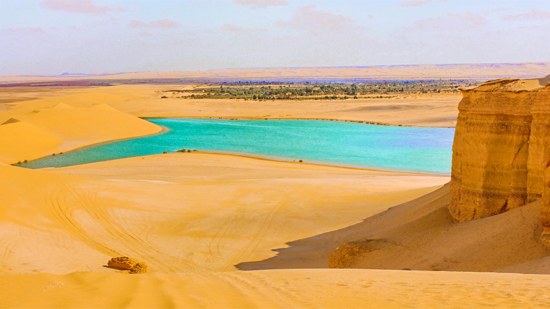
The Magic Lake is one of the most beautiful lakes in Egypt. It looks out over the sand hills of Wadi El Hitan. Going around the lake, you can see one of the most beautiful sunsets you will ever see. In Fayoum, the Magic Lake in Wadi El Hitan is beautiful. The name “Magic Lake” comes from its color changing several times daily based on the season and the sunlight it gets. The desert all around it makes it look even more beautiful. Some people like to hike and sandboard next to Magic Lake or swim in the lake. People with gout are said to benefit from the minerals in the lake.
Book [ Fayoum Oasis Layover Tour From Cairo by Car ]
2- Lake Nasser
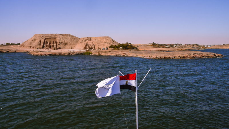
Lake Nasser is a vast reservoir in southern Egypt and northern Sudan, created due to the construction of the Aswan High Dam. The dam was built across the Nile River between 1960 and 1970, with the primary purpose of regulating the flow of the Nile, controlling floods, and providing hydroelectric power. Key points about Lake Nasser:
- Formation: The lake was formed as the Nile River filled the space behind the Aswan High Dam, located near Aswan in southern Egypt. Construction of the dam began in 1960 and was completed in 1970.
- Size: Lake Nasser is one of the largest artificial lakes in the world. It stretches approximately 550 kilometers (340 miles) in length and has a maximum width of about 35 kilometers (22 miles) at its widest point. The lake covers an area of about 5,250 square kilometers (2,030 square miles).
- Purpose: The Aswan High Dam and Lake Nasser have multiple purposes, including flood control, irrigation, and the generation of hydroelectric power. The dam has significantly reduced the frequency and severity of floods along the Nile, and it has facilitated the expansion of agriculture through controlled irrigation.
- Hydroelectric Power: The dam has a substantial hydroelectric power station that generates electricity for both Egypt and Sudan. The power generated from the dam has been crucial for the economic development of the region.
- Archaeological Impact: The creation of Lake Nasser led to the relocation of numerous archaeological sites and monuments, including the famous temples of Abu Simbel. To preserve these historical treasures, an extensive international effort was made to relocate and protect them from being submerged under the lake’s waters.
- Tourism: Lake Nasser has become a popular destination for tourism, offering boat cruises that provide visitors with the opportunity to explore the vast expanse of the lake and visit archaeological sites along its shores.
3- Lake Moeris

Lake Moeris, also called Lake Moeris or Qarun Lake, is an ancient lake in the Faiyum Oasis of Egypt. It is a natural depression located southwest of Cairo and was connected to the Nile River by canals. Lake Moeris played a significant role in the agricultural and economic development of the region in ancient times. Here are key points about Lake Moeris:
- Artificial Lake: Although Lake Moeris is often referred to as a natural lake, it was, in fact, an artificial or enhanced lake. It was expanded and regulated by various pharaohs of ancient Egypt, including Amenemhat III of the 12th Dynasty. The lake was connected to the Nile by a system of canals and sluices, allowing for controlled water flow.
- Agricultural Importance: Lake Moeris served as a vital component of the agricultural system in the Faiyum region. The controlled release of water from the lake helped irrigate the surrounding land, supporting agriculture and increasing the fertility of the soil.
- Water Management: The ancient Egyptians developed sophisticated systems of water management to control the level of Lake Moeris and regulate the flow of water into the adjacent areas. The lake played a role in mitigating the impact of Nile River floods and ensuring a more stable water supply for agriculture.
- Economic Hub: The Faiyum Oasis, with Lake Moeris at its center, became an economic hub in ancient Egypt. The fertile land around the lake was used for agriculture, and the lake itself supported fishing and other water-related activities.
- Herodotus’ Account: The Greek historian Herodotus wrote about Lake Moeris in his work “Histories.” According to Herodotus, the lake was artificial and served as a reservoir to store excess floodwaters during the inundation of the Nile.
- Modern Status: Over the centuries, the size and importance of Lake Moeris diminished. While it once covered a larger area, it has largely dried up, leaving a smaller and more saline remnant. Today, the region around the ancient lake is known for its archaeological sites and the remnants of the ancient water management system.
4- Lake Timsah

Lake Timsah, also known as Crocodile Lake, is a small saltwater lake in the Ismailia Governorate of Egypt. It is situated in the northern part of the Suez Canal, near Ismailia. The lake is an integral part of the Suez Canal waterway system. Here are key points about Lake Timsah:
- Geography: Lake Timsah is a natural lake with an area of about 5.5 square kilometers (2.1 square miles). It is relatively shallow, with a maximum depth of around 3 meters (10 feet).
- Suez Canal Connection: The lake is connected to the Suez Canal and serves as a widening of the canal system. It provides a place for ships to turn around and adjust their positions before continuing their journey through the canal.
- Name: The name “Timsah” means “crocodile” in Arabic. The lake earned this name due to the presence of crocodiles in the area in ancient times. However, crocodiles are no longer found in the lake or the surrounding region.
- History: Lake Timsah has historical significance as it played a role during the construction of the Suez Canal in the 19th century. The lake was initially much larger, and its size was reduced during the canal’s construction to make way for the waterway.
- Economic Importance: The lake, along with the entire Suez Canal, is a crucial waterway for global maritime trade. The Suez Canal connects the Mediterranean Sea to the Red Sea, providing a shorter maritime route between Europe and Asia. Lake Timsah facilitates the movement of ships through the canal.
- Wildlife: While the lake has undergone changes over the years, it still supports some aquatic life. Various bird species, fish, and other wildlife can be found in and around Lake Timsah.
- Recreational Activities: The lake and its surroundings offer recreational opportunities, and parks and promenades are along its shores. It has become a popular spot for locals and visitors to enjoy outdoor activities.
5- The Salt Lakes of Siwa

Siwa Oasis, located in the western desert of Egypt near the Libyan border, is known for its unique and picturesque landscapes, including a series of salt lakes. The salt lakes of Siwa are natural formations that add to the oasis’s beauty and attract visitors interested in exploring the desert environment. Here are key points about the salt lakes of Siwa:
- Geography: Siwa Oasis is situated in the depression of the Libyan Desert and is surrounded by dunes and salt flats. The salt lakes are scattered around the oasis, contributing to the region’s diverse ecosystem.
- Salt Pans: The salt lakes are often referred to as salt pans, as they are typically shallow depressions filled with saltwater. The high evaporation rates in the desert environment lead to the concentration of salts, leaving behind a layer of crystallized salt on the lakebeds.
- Ain Dakrour: One of the notable salt lakes in Siwa is Ain Dakrour, known for its unique scenery with salt-encrusted shores and the surrounding desert landscape. The lake provides a tranquil and reflective environment, creating a picturesque setting.
- Ecological Significance: The salt lakes of Siwa, though harsh environments play a role in the local ecology. They provide habitat for certain species of plants and microorganisms adapted to saline conditions. The lakes are also visited by migratory birds, adding to the biodiversity of the area.
- Tourist Attractions: The salt lakes contribute to the appeal of Siwa Oasis as a tourist destination. Visitors to Siwa have the opportunity to explore the lakes, take in the stunning views, and appreciate the contrast between the salt flats and the surrounding desert landscapes.
- Healing Properties: Some people believe that the salt in the lakes has therapeutic properties, and mud from the lakes is occasionally used for skincare. However, it’s important to note that any health-related claims should be approached with caution, and visitors should be mindful of the environmental impact.
- Cultural Significance: Siwa Oasis has a rich cultural history, and the salt lakes are part of the broader natural and cultural heritage of the region. The oasis is known for its ancient sites, including the Temple of the Oracle at Aghurmi.
6- Lakes of Wadi Al-Rayan

Wadi Al-Rayan is a unique natural area in the Fayoum Governorate of Egypt, southwest of Cairo. It is known for its series of lakes and waterfalls, and it has been designated as a protected area to preserve its natural beauty and biodiversity. The lakes of Wadi Al-Rayan are artificial lakes created by human intervention, and they serve as a prominent attraction in the region. Here are key points about the lakes of Wadi Al-Rayan:
- Artificial Creation: The lakes of Wadi Al-Rayan were formed by the overflow of agricultural drainage water from nearby farms into the depression of the Wadi Al-Rayan valley. The project was initiated in the 1970s to manage excess water and prevent flooding in the Fayoum region.
- Two Lakes: Wadi Al-Rayan consists of two main lakes: Lake Al-Rayan I and Lake Al-Rayan II. These lakes are interconnected, and their water levels vary based on agricultural runoff and rainfall.
- Waterfalls: One of the distinctive features of Wadi Al-Rayan is the presence of waterfalls that connect the two lakes. These waterfalls are formed by water flow from the higher to the lower lake, creating a scenic and serene environment.
- Biodiversity: The lakes and the surrounding Wadi Al-Rayan area support various plant and animal species. The lakes attract migratory birds, making it a notable destination for birdwatching enthusiasts. The protected area is home to various desert plants and wildlife adapted to the arid environment.
- Tourist Attraction: Wadi Al-Rayan has become a popular tourist destination, allowing visitors to enjoy the natural beauty of the lakes, waterfalls, and the surrounding desert landscape. The area has developed infrastructure for tourists, including picnic areas and viewpoints.
- Conservation: In 2005, Wadi Al-Rayan was designated a protected area to conserve its ecological significance and promote sustainable tourism. Conservation efforts aim to preserve the region’s unique natural features and protect the habitat for the diverse flora and fauna.
- Recreational Activities: Visitors to Wadi Al-Rayan can engage in various recreational activities, including picnicking, swimming, and hiking. The tranquil setting and the contrast of water features in the desert make it a popular spot for relaxation and outdoor enjoyment.
7- Lake Burullus

Lake Burullus is a large brackish lagoon in northern Egypt’s Nile Delta region. It is one of the country’s major coastal lakes near the Mediterranean Sea. The lake has ecological significance and supports diverse flora and fauna. Here are key points about Lake Burullus:
- Geography: Lake Burullus is situated in the Nile Delta, northwest of Cairo, and is located east of the Rosetta branch of the Nile. It is separated from the Mediterranean Sea by a narrow sandbar.
- Size: The lake covers an area of approximately 450 square kilometers (174 square miles), making it one of the largest coastal lakes in Egypt.
- Brackish Water: Lake Burullus is characterized by brackish water, a mix of freshwater from the Nile River and seawater from the Mediterranean. This brackish environment influences the types of plants and animals that inhabit the lake.
- Ecological Importance: The lake is an important habitat for various bird species, including migratory birds that use it as a journey stop. It provides breeding grounds for several waterfowl, making it a significant site for birdwatching and wildlife conservation.
- Fisheries: The brackish waters of Lake Burullus support a variety of fish species, making it an important area for fisheries. Fishing is a traditional economic activity for local communities around the lake.
- Threats and Conservation: Like many ecosystems, Lake Burullus faces challenges, including habitat loss, pollution, and changes in water quality. Conservation efforts aim to address these challenges and protect the lake’s biodiversity. Measures include monitoring water quality, controlling pollution, and managing fisheries sustainably.
- Tourism: Lake Burullus, with its diverse birdlife and natural beauty, has the potential to attract eco-tourists and birdwatchers. Efforts to promote responsible tourism can contribute to the local economy and the conservation of the lake.
- Cultural Significance: The lake has cultural importance for the local communities around its shores, influencing traditions, livelihoods, and local practices.
8- Lake Mariout
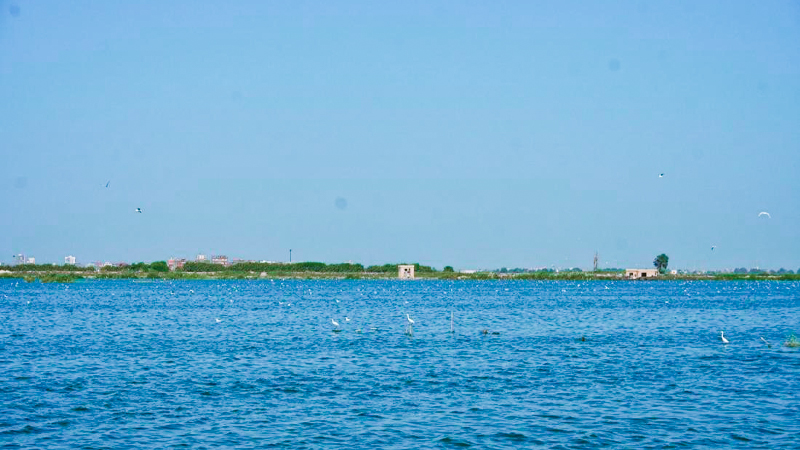
Lake Mariout, also known as Mariut or Mareotis, is a brackish lake near the Mediterranean coast in the Alexandria Governorate of Egypt. The lake has historical, cultural, and ecological significance and has undergone various changes over the centuries. Here are key points about Lake Mariout:
- Geography: Lake Mariout is situated west of Alexandria and is connected to the Mediterranean Sea by a narrow channel. It is a coastal lagoon with brackish water, representing a mixture of freshwater and seawater.
- Size and Depth: The lake covers an area of about 250 square kilometers (97 square miles). It is relatively shallow, with an average depth of around 1 meter (3.3 feet).
- Historical Significance: In ancient times, Lake Mariout was a much larger lake and played a role in the economic and agricultural activities of the region. The lake was part of a complex system of canals and basins that facilitated irrigation and supported agriculture.
- Water Sources: Lake Mariout receives water from various sources, including agricultural runoff, drainage from surrounding areas, and some freshwater inflow. The connection to the Mediterranean Sea allows for the exchange of water.
- Ecosystem: The lake and its surrounding areas support a diverse ecosystem, including various bird species. It is an important site for birdwatching, particularly during the migration season when birds stop at the lake.
- Human Activities: The lake has been subject to human activities and development, impacting its size and ecological balance. Urbanization, agriculture, and industrial activities in the surrounding areas have contributed to lake ecosystem changes.
- Salinity: Due to its connection to the Mediterranean and the inflow of brackish water, Lake Mariout has a higher salinity than freshwater lakes. The salinity levels can vary based on seasonal and environmental factors.
- Conservation Efforts: Over the years, there have been efforts to address environmental concerns and restore the ecological balance of Lake Mariout. Conservation initiatives aim to mitigate pollution, manage water resources, and protect the area’s biodiversity.
- Cultural Heritage: The historical significance of Lake Mariout is reflected in its association with ancient Alexandria and the region’s cultural heritage. It has been mentioned in historical texts and literature.
9- Great Bitter Lakes

The Great Bitter Lakes are a series of saltwater lakes in Egypt, located along the northern part of the Suez Canal. These lakes are part of the Suez Canal’s overall water system and play a specific role in the navigation and operation of the canal. Here are key points about the Great Bitter Lakes:
- Location: The Great Bitter Lakes are situated in northeastern Egypt, near the Suez Canal. They are located between the northern and southern portions of the canal, serving as a crucial component of the waterway.
- Formation: The lakes are not naturally occurring but are part of the Suez Canal’s construction. They were created during the canal’s development in the 19th century due to excavations and the redirection of water from the Mediterranean Sea and the Red Sea.
- Saltwater: The lakes are saline or saltwater lakes, and their salinity is influenced by the connection to the Mediterranean Sea in the north and the Red Sea in the south. The salt concentration in the lakes is higher than that of ordinary seawater.
- Role in Suez Canal Operation: The Great Bitter Lakes serve a specific purpose in the operation of the Suez Canal. They function as a wider section of the canal, allowing for the passage of ships traveling in opposite directions to meet and pass each other. The lakes allow ships to anchor, wait, or adjust their positions.
- Navigation Control: The lakes are crucial in controlling maritime traffic through the Suez Canal. The widened area allows for safe and efficient navigation, reducing the risk of collisions and facilitating the movement of vessels through the canal.
- Bypassing Station: Besides their role in navigation, the Great Bitter Lakes also function as a bypassing station where ships can wait for their turn to traverse the canal. This is particularly important in the case of heavy traffic or maintenance operations within the canal.
- Wildlife: Despite the high salinity levels, the Great Bitter Lakes support some forms of microbial life and are visited by migratory birds. The lakes are part of the wider ecosystem of the Suez Canal region.
- Historical Significance: The lakes have historical significance, linked to the Suez Canal’s development and its strategic importance in global trade. The canal and the lakes have played a role in international maritime history and have been subject to geopolitical events.
10- Bardawil Lake
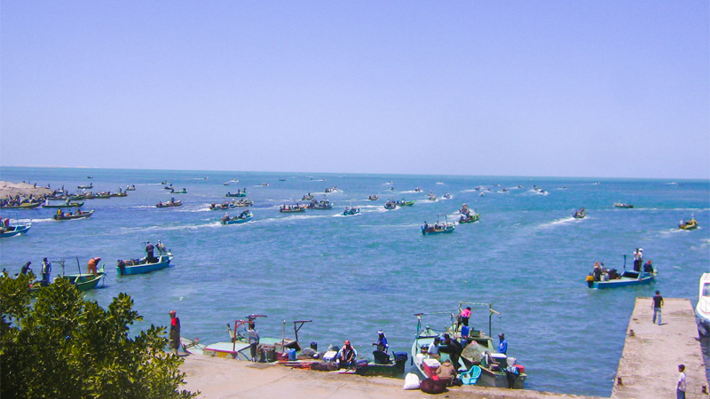
Lake Bardawil, also known as Bardawil Lagoon, is a large coastal lagoon located in the northern Sinai Peninsula of Egypt. It is situated between the Mediterranean Sea and the Sinai Desert and is known for its unique ecological characteristics. Here are key points about Bardawil Lake:
- Geography: Lake Bardawil is a shallow coastal lagoon with an area of approximately 430 square kilometers (166 square miles). It is elongated and stretches along the Mediterranean coastline of northern Sinai.
- Connection to the Mediterranean Sea: The lake is directly connected to the Mediterranean Sea through a narrow inlet. The exchange of water with the sea influences the salinity levels of the lake.
- Salinity: Bardawil Lake is a hypersaline lagoon with higher salinity levels than typical seawater. The combination of evaporation and limited freshwater input contributes to the elevated salinity of the lake.
- Fluctuating Water Levels: The water levels in Lake Bardawil can fluctuate based on factors such as evaporation, precipitation, and changes in seawater inflow. Seasonal variations can impact the size of the lake.
- Ecological Importance: The lake is recognized for its ecological significance, serving as a habitat for various bird species, including migratory birds. It is an important site for birdwatching and contributes to the region’s biodiversity.
- Vegetation: The lake is surrounded by dunes and supports some vegetation. The vegetation includes salt-tolerant plants adapted to the arid conditions of the Sinai Peninsula.
- Fisheries: Lake Bardawil has traditionally been important for local fisheries. The lake supports various fish species adapted to brackish and hypersaline conditions, providing a livelihood for local communities.
- Tourism: The natural beauty of Lake Bardawil and surroundings make it an attraction for eco-tourists and nature enthusiasts. The lake offers opportunities for birdwatching, and its tranquil environment contrasts the nearby desert landscape.
- Protection: Lake Bardawil and its ecosystem have been recognized for their environmental value. Efforts have been made to protect the lake and its surroundings, balancing human activities with conservation measures.
- Historical Context: The lake has historical significance as part of the broader Sinai Peninsula, an area with a rich history dating back to ancient times. The lake’s location has made it a point of interest for various civilizations throughout history.
11- Toshka Lakes

The beautiful Toshka lakes were formed when the amazing Lake Nasser would overflow from time to time. This was a key part of starting the Toshka New Valley project. The high water levels from the Nile rains that spilled into the Toshka region around 1988 created the lakes of Toshka. Astronauts on the International Space Station saw these lakes grow.The land area of Toshka Lakes is 1,450 km2, which is 560 sq mi, and the lowest area is about 307 km2, which is 119 sq mi. The water level is about 25.26 km3, which is 10 cu mi. It is known that the Toshka lakes are very salty and can’t drain to the sea. Between 2006 and 2019, the area and the water have changed because of both natural and man-made changes made to help farming and the local business.
12- Lake Manzala
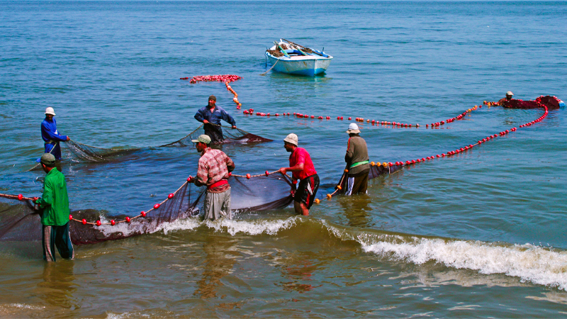
Lake Manzala is one of the largest brackish lakes in Egypt and is situated in the northeastern part of the Nile Delta. Here are key points about Lake Manzala:
- Geography: Lake Manzala is located in the northeastern part of the Nile Delta, bordered by the Mediterranean Sea to the north. It is connected to the Mediterranean through a narrow strip of land.
- Size: The lake covers an area of approximately 1,450 square kilometers (560 square miles), making it one of the largest lakes in Egypt.
- Brackish Water: Lake Manzala is characterized by brackish water, a mixture of freshwater from the Nile River and seawater from the Mediterranean. The lake’s salinity can vary depending on seasonal variations and water management practices.
- Fluctuating Water Levels: The water levels in Lake Manzala can fluctuate due to factors like seasonal variations in rainfall, agricultural activities, and the regulation of water flow from the Nile.
- Economic Significance: The lake has been historically important for fisheries, providing a livelihood for local communities. Fishing in Lake Manzala has been a traditional economic activity, supporting the livelihoods of many families in the region.
- Environmental Challenges: Lake Manzala has faced environmental challenges over the years, including pollution, habitat degradation, and changes in water quality. Human activities, industrial discharges, and agricultural runoff have contributed to these challenges.
- Birdlife: Despite environmental issues, Lake Manzala remains an important site for birdwatching. The lake and its surroundings attract various bird species, including migratory birds, making it a significant area for avian biodiversity.
- Conservation Efforts: Efforts have been made to address environmental concerns and promote the sustainable use of Lake Manzala’s resources. Conservation initiatives aim to protect the lake’s biodiversity and ensure the well-being of local communities.
- Land Reclamation Projects: Like other areas in the Nile Delta, Lake Manzala has been affected by land reclamation projects. These projects involve converting parts of the lake into agricultural land, which can affect the lake’s ecosystem and water dynamics.
- Cultural Significance: Lake Manzala and its surroundings have cultural significance in the context of the Nile Delta and its historical and agricultural heritage.
13- Edko Lake
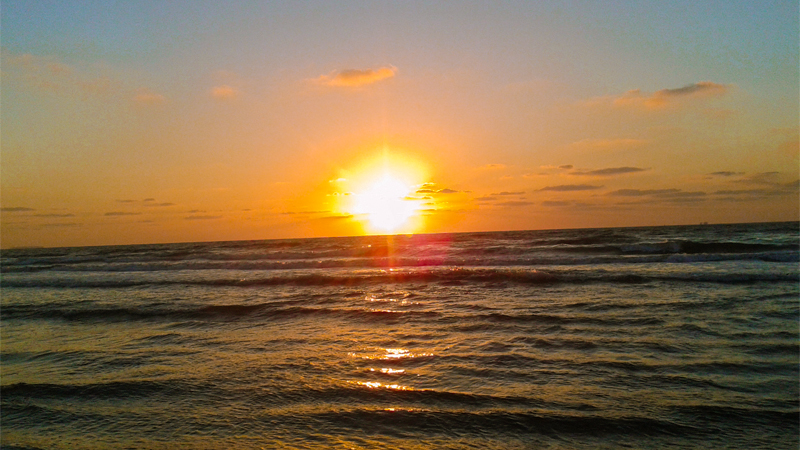
One of the most beautiful lakes is Idku Lake, which is 62.78 square kilometers (24.24 square miles) of fresh water and connects to the Mediterranean Sea. The environment around the lake and its edges is very diverse. This is true west of the Rashid branch, where the fine dunes make a magical scenery full of the most beautiful plants and animals. Lake Idku has a unique environment because it is where fresh water meets salty sea water. This is why it has so many resources. A lot of different human tasks are fighting to use it.
What is the biggest lake in egypt?
The largest lake in Egypt is Lake Nasser. Lake Nasser is a vast reservoir formed by the construction of the Aswan High Dam on the Nile River. It is one of the largest artificial lakes in the world, extending across the border between Egypt and Sudan. The creation of Lake Nasser was part of the Aswan High Dam project, completed in 1970, which aimed to regulate the flow of the Nile, control floods, and generate hydroelectric power. The lake has a significant impact on the region’s water management, agriculture, and energy production.
What are the most beautiful lakes in Egypt?
Egypt is home to several lakes, each with its own unique charm and beauty. While opinions on what makes a lake “the most beautiful” can vary, here are some lakes in Egypt that are often considered attractive and picturesque:
- Lake Nasser: The sheer size and expanse of Lake Nasser, especially against the backdrop of the surrounding desert landscape, can be awe-inspiring. The lake is also known for its historic sites and archaeological monuments.
- Wadi Al-Rayan Lakes: Located in the Faiyum Oasis, these artificial lakes are known for their scenic beauty and the contrast they provide to the desert surroundings. The area is also home to diverse wildlife.
- Lake Bardawil: Situated in northern Sinai, Lake Bardawil is known for its coastal beauty and the contrast between the saltwater lake and the nearby sand dunes. It’s a tranquil spot and attracts birdwatchers.
- Lake Manzala: Despite environmental challenges, Lake Manzala is known for its vastness and the variety of bird species that inhabit the area. It’s a significant location for birdwatching.
- Bitter Lakes (Great Bitter Lake): These lakes along the Suez Canal are unique and attract attention due to their strategic location and the historical significance of the canal.
- Lake Burullus: This brackish lake in the Nile Delta is important not only for its ecological diversity but also for its picturesque views, especially during sunrise and sunset.
- Lake Timsah: Another lake along the Suez Canal, Lake Timsah provides a scenic setting and is a popular spot for boat cruises.
The beauty of a lake is subjective, and it often depends on personal preferences and interests. Some people may appreciate the natural scenery, while others might find historical or cultural aspects equally appealing. When visiting these lakes, travelers can also enjoy the surrounding landscapes, local flora and fauna, and the cultural and historical context that each lake contributes to its region.
Famous Salt Lakes in Egypt 2024/2025
Egypt is home to several salt lakes characterized by high salinity levels. These lakes often result from the evaporation of water, leaving behind concentrated salts. Here are some notable salt lakes in Egypt:
- Siwa Salt Lakes: Located in the Siwa Oasis in the Western Desert, these salt lakes are known for their striking white landscapes. The lakes are surrounded by desert scenery, creating a unique and picturesque environment.
- Qarun Salt Lake: Also known as Lake Moeris or Birket Qarun, this is a brackish lake in the Faiyum Oasis. It has a high concentration of salts, and its salinity varies depending on the season. The lake is important for its ecological diversity and historical significance.
- Lake Natron (partly in Egypt): While most of Lake Natron is located in Tanzania, a small portion extends into Egypt. Lake Natron is known for its extremely high alkalinity and distinctive red color, caused by the presence of microorganisms.
- Lake Katamya: This is a small saltwater lake located in the northeastern part of Cairo. While not a natural salt lake, it has gained salinity due to its connection to the Nile and limited water exchange.
- Edko Salt Pan: The Edko Salt Pan is an area with salt flats near Edko village on the Mediterranean coast. It is known for salt extraction activities and the creation of salt pans.
These salt lakes contribute to the unique landscapes of Egypt and may also have economic importance, such as in the extraction of salt. The high salinity of these lakes often creates visually stunning scenes, attracting photographers and nature enthusiasts. It’s important to note that the characteristics of salt lakes can change over time due to environmental factors and human activities.

